Here’s some photos from an adventurous 7 day mountain bike tour we embarked on the Barranca Del Cobre (Copper Canyon) just a few days after arriving in Mexico. Read the full story below [Caution: it’s long].
Three days into our Mexico trip we were heading for Creel, a small rural town sitting at 2377 metres on the high mesa surrounding the Barranca Del Cobre (Copper Canyon). We’ve heard stories of a canyon deeper and broader than the USA’s Grand Canyon and were keen to explore the area.
Part of a national park, The Barranca Del Cobre is one of a series of 1800 metre deep canyons that slice up a large section of the Sierra Madre Occidental – Mexico’s largest mountain range. It’s a tourist spot, if you can call it that: we were two of the total of six tourists in town, but that’s just how we like it. Most visitors here see the canyon via a railway that heads out to the Pacific coast, but we’d found some info on the internet about the area’s mountain biking potential – as well as heaps of climbing possibilities.
A man by the name of Arturo was said to have to the beta for riding in the area, and we spent the better part of our first afternoon in Creel trying to track him down (with multiple possible locations and contradictory directions from the locals). Eventually we found out he was on his way to Chihuahua! Our plan was try and do a several-day cycle tour (mostly on dirt roads) down into the canyons, and over a couple of ranges, making an approximately 400km loop back to Creel. Finding out sufficient details to be confident to embark on the trip was tricky and we dedicated a second day to trying to get as much info from the internet and around town as we could.
A very helpful English-speaking guy from the Three Amigos gave us a basic hand drawn map with some towns (and some altitudes) marked, but none of the side roads and no real indication of the topography apart from where the rivers were. Apart from that we knew that some sections descended from 2300 metres to 300 metres and some climbed back that far! Google Earth revealed a few more details, but in many spots we could only guess as to which road was ours as many of the villages aren’t labelled.
We vaguely fine tuned our route after reading lots of posts from motor cyclists and four wheel drive enthusiasts on internet forums. There we found a road-log that recorded key turns and landmarks – this proved essential as there were many unmarked junctions in the middle of nowhere. Despite extensive searching we couldn’t find a single account of anyone who had attempted the mountainous loop via mountain bike.
Adding to our uncertainly was the prospect of being robbed on the road section from Batopilas to Tubares (there had been four robberies of locals a month during 2008). Locals had apparently started driving that road in convoy or with the mining trucks.
An even bigger fear was of the drug cartels. The Barranca Del Cobre region is one of the biggest for marijuana cultivation in the whole of Mexico and we had read several accounts of four wheel drivers encountering groups of men with automatic weapons, large sacks, and threatening expressions. Despite the encounters, every one we read of involved both parties going their own way. It seems the cartels generally have little issue with tourists as long as they mind their own business. Being the off-season for harvest we hoped the risk would be lowered – and I stashed a 500 peso note in my seat tube just in case we did lose our cash to robbery or bribery.
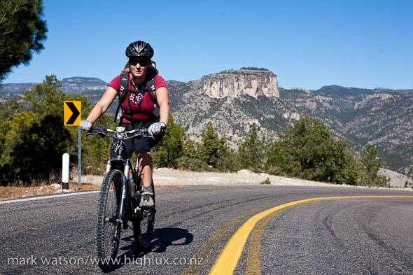 Day 1 :: Creel – Basigochi [82km]
At well over 2300 metres Creel sees cold temps and after another -10° night the bikes were thick with frost when we woke at 7 am. By 8.30 most of the frost had melted off and with light backpacks on we pedalled out of town on a good sealed road.
We’d packed light, with just a day pack each and no panniers – knowing that on at least three nights we’d be able to get paid accommodation in basic village hotels. The rest of the time we hoped to be at low enough altitude to bivvy comfortably with the two blankets and single ¾ thermarest we carried. Beyond a blanket each, we had just enough clothes to keep warm, some tools and spare tubes, a GPS, and a small amount of food – we hoped to buy more as went in small village stores, as well as sometimes eating lunch and dinner in village restaurants here and there. I’m also carrying my SLR, but with a 50mm lens only to save weight.
Mostly downhill, the first 40 km sped by and soon we were eating lunch at the bottom of the upper section of Copper Canyon itself. Apart from the odd bit of local traffic the ride had been very quiet. Just the occasional tiny village, with hut chimneys spiralling smoke into the crisp winter air. Many of the people living in these parts of the reclusive Tarahumara mountain people – recognisably different to typical ‘Mestizo’ Mexicans and distinctive for the bright dresses worn by females.
We’d read of the huge climb out from Copper Canyon – back to mesa level – but hadn’t imagined it might take us the whole afternoon to climb from 1600 metres back to 2300 metres on the mesa top. We really feel the altitude and by the time we top the climb and reached the terminus of the sealed road at Napuchis it was late afternoon. The road turned to dirt, and we pedalled on – hoping the massive, switchbacked drop into the deeper Batopilas Canyon would come soon, taking us to a lower altitude for a reasonable bivvy.
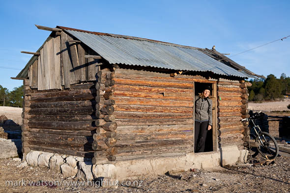 The drop never came, and it was just on dark as we crawled into Basigochi – a village consisting of not much more than a few clusters of huts and a small school building. Desperate not to have to bivvy still above 200 metres we ride to the nearest hut and call ‘Hola!’ as we tap on the door. There’s a whole family hanging out inside, and a fancy electronic keyboard and speakers sitting in the dirt and farm crud by the front door.
With some shaky Spanish, Hana says to the young guy who opens the door that ‘We need a bed for the night’ and that we’re heading to ‘Batopilas mañana’. The young guy appreciates our situation and while we can’t understand his reply very well we soon work out that he’s offering us a tiny casita (hut) next to theirs. It’s damp, the floor’s dirt and mud, but it has a wooden board bed and blankets and is one hell of a lot better than huddling round a fire with frosty blankets on our shoulders.
‘¡Esta bien!’ we reply as he offers us the hut and with that we are left to ourselves for the night. Sitting on the bed we eat our beans and tortillas and with 82km of hilly riding under our tyres soon pass out.
 Day 2 & 3 :: Basigochi – Batopilas [55km]
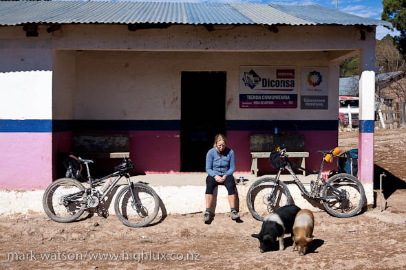
After a 10 hour sleep we wake to a slightly warmer morning and after a breakfast of biscuits are pedalling again on the rolling dirt road. After 20km or so we pass through Kirare and stop briefly at the shop there for a second breakfast. It’s another small village, consisting of a few basic houses, a concrete block schoolhouse and one shop that sells mostly junk food, a few vegies and refrescos (soft drinks) – typical of most of the small villages we pass through en route.
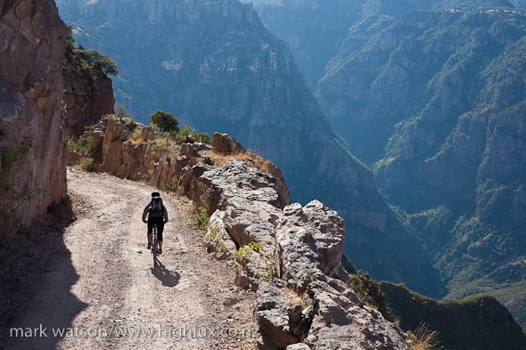
From Kirare the road heads down an open valley, and drops and drops. The terrain steepens, and the road – quite an engineering feat – clings precipitously to the valley’s side. It’s pretty clear we’re finally dropping into the main Batopilas Canyon, and as we round a bend the whole world drops away. From here the road descends in several hundred metres of sinuous switchbacks to a small bridge on the valley floor. After two days of mostly rolling terrain it’s great to be plummeting down the hill.
Halfway down we pause at a solitary house on one switchback as the road is covered with goats. As we resume our drop a crazed dog runs from nowhere. It’s barking in a frenzy and sprints after Hana. Chasing dogs rarely actually bite cyclists (from my experiences), but this one wanted lunch, and it liked the look of Hana’s lower leg. In a quick lunge it sinks its teeth in and won’t let go – it’s no casual nip, and by the time it does release its grip (the owners were throwing rocks at it), Hana’s got two rows of teethmarks oozing blood, and a fat haematoma starting to appear.
We punch it down the road further to get away from any more dog-assaults and then stop to clean up the wound. Infection is a worry, along with rabies. Although we have both had rabies immunisation, you still need two post-exposure booster injections.
The switchbacks take us into the bottom of the valley, and once across a sketchy looking bridge it’s mostly downhill for the next 35 kilometres. By the time we reach Batopilas, our stop for the next two nights, we’ll have descended 1900 metres from Basigochi. The road is a single lane dirt road and makes for fun riding as it weaves its way in and out of gullies and over small streams. The canyon’s spectacular with massive limestone cliffs and towers.
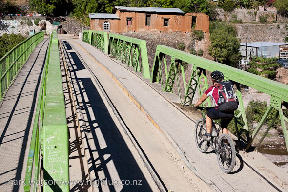 By 2.30pm we’re in Batopilas and after the scruffy and spartan villages we’ve been passing for the past two days, this town is quite a contrast. A Spanish colonial town, it was built during a silver mining boom that helped the region prosper in the 19th century. Until the 1970s though, the only way in and out was via a goat track – the road wasn’t constructed until 1975. Constrained by the tight river valley, Batopilas is mostly a single-road town and has a very European charm to it, with cobbled streets, a central plaza (square), and tight corridors. Leaves litter the town’s single road, kids play in the street and old men chatter in doorways. For tired cyclists it’s an oasis.
We check into a budget hotel called Casa Monse for the night and spend the rest of the afternoon cruising around town. We get Hana’s leg cleaned and inspected at the medical clinic (a true language challenge), and enjoy the mellow ambiance of town, meeting a few of the handful of tourists in town for the night. At only 400 metres the climate feels almost tropical compared to the frosts and cold wind up high. We take the next day off the bikes to recover more (the only way out of town for us is a 800 metre elevation gain on a steep 4WD road).
 Day 4 :: Batopilas – Tubares [66.5km]
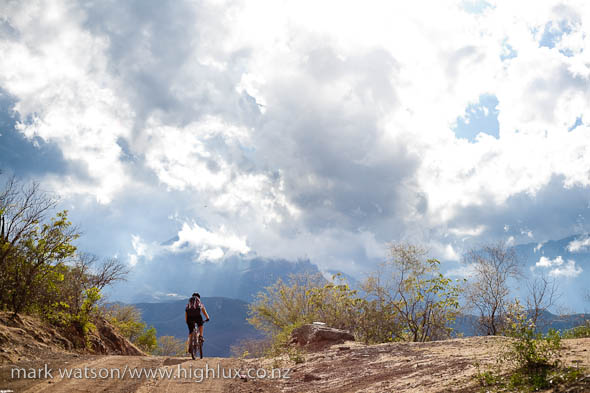
On fresh legs we ride out of town and within half a kilometre of the plaza the road to Tubares leaves the valley and heads steeply straight uphill. We settle into the rhythm of the climb and spent the next three hours mostly in first and second gear. As we climb we get awesome views down into Batopilas and the surrounding canyons and ranges. The terrain looks a little like Banks Peninsula, but with everything doubled in size.
The sky darkens and the wind picks up as we gain height and by the time we hit the saddle, 800 metres above Batopilas, it’s raining. To save weight we’d left shells behind and have just windproof jackets, so we suck it up and keep climbing and are soon soaked to the skin. The road weaves its way along high ridges for a few more kilometres and eventually tips and we finally enjoy the pull of gravity as we roll down the twisting descent. At one point we ride into some incredibly sticky mud that immobilises both bikes until we scrape it off with sticks. What’s left of it soon sets like concrete.
Half an hour later the showers have eased off and wet through and shivering we pedal down the broadening valley into Rodeo. The town’s stark, apparently almost deserted and kinda spooky. A single Mexican sits leaning against a tree in the dusty plaza area and I keep expecting tumbleweeds to blow past. The shop there provides for our lunch and after scraping off some more mud and drying out a bit we’re off again in the direction of San Ignacio. The topography has changed significantly and we’re riding down a broad scrubby valley, riven with the occasional arroyo (dry riverbed). Our, by now tattered and soggy, road log doesn’t match the terrain any longer and after passing a couple of unmarked intersections we stop and ask at a house to make sure we’re on track.
The valley’s a nice ride after the verticality of the morning and we make good time as we approach the Rio San Ignacio. The road swings alongside the river here, passing through the town, and then climbing over a pass to the Rio Urique which we’ll have to ford. The road log describes the climb as a ‘mountain pass’, but fortunately the climb’s not much more than 400 metres and soon we plunge down the other side to the river. There’s a bridge under construction at the river, but work has halted, and there’s a single old man sifting around there who we figure is paid to keep an eye on the equipment. We ask about the river and he shows us the best spot to cross, before asking if we have any food or cerveza for him. Shaking our heads we thank the lonely old guy and wade our way across the narrow river channel. More climbing ensues on the other side as we climb another small pass before the descent to Tubares.
It’s only an hour or so from dark as we pull up at a small shop by the bridge across to the village. We know there’s no hotels or accommodation here, but hope the shop might be able to direct us to someone who might be able to give us a bed for the night, Our requests are met with blank looks and shaking heads though, so we buy a big can of pork stew for dinner and ride over the bridge hoping for better luck on the other side.
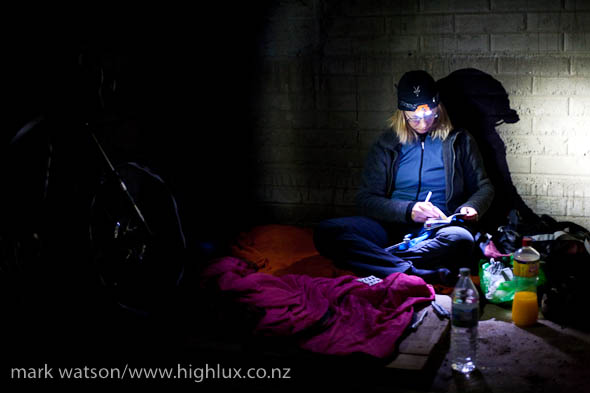 Riding up to the largest house in the village, we ask again regarding somewhere to sleep and a man there directs us to a half constructed concrete shell of a house just over the road. It’s no bed, but it’s an ideal bivvy spot and we thankfully accept his offer. We’re at 300 metres, so should be warm enough for the night. Among the trash lying around the half-house is a wooden pallet which we use to insulate ourselves from the concrete floor. The thermarest I’ve carried for the past three days of riding appears to have a hole in it, so it looks like it might be an uncomfortable night! We eat half of our can of pork and corn stew before giving up on it and I spend the next couple of hours obsessively cleaning the drive trains on the bikes. It’s about 9pm when we curl up on the pallet wearing all of our clothes and with a single blanket over the top of us. Somehow we both sleep well for 10 hours and wake to a foggy morning the following day.
 Day 5 :: Tubares to Cinequita [38km riding/10km via truck]
If there’s going to be a ‘queen stage’ to this tour we reckon that today will be it. There’s at least 2000 metres of climbing to get us to the town of Piedras Verdes where again it will be a gamble as to whether we can find a bed for the night. All we really know is that we’re at 300 metres and that Piedras Verdes is at 2000 metres – we have no idea if that height gain is made on one big hill, or via a few heart-breaking climbs and descents.
Breakfast is biscuits, bananas and a big hit of instant coffee mixed with cold water. Our little bag of Nescafe is the easiest way to get a caffeine hit with no stove, and we take further doses later in the day to help keep our leg tempo up – it works wonders when you’re flagging a bit. We cross the river and head towards a switchback road in the distance that climbs onto the range. The sun soon burns off the morning fog and we start climbing. Soon we’re relegated to first and second gear again as we grind up the road. Several hours later we stop for lunch with nothing but twisting 4WD road above and below us – we’ve been climbing continuously all morning, seeing the occasional Tarahumara dwelling and not a lot else. Now and then the road drops a bit, but it’s always soon back to steep climbing. We push our bikes on a couple of extra steep sections, and spend the rest of the afternoon seeing how much power we can eke out of our quads. I’m constantly amazed at what we can juice out of our legs after so much climbing in the last two days. It’s taking its toll on the rest of our bodies though and by the middle of the day the constant steep climbing is giving us sore backs, not to mention our arses.
Eventually we arrive in Piedras Verdes, our intended spot for the night, around 4pm. The village is in a cold and shady gully, but has a lot more charm than many we’ve passed through. The locals are pretty friendly too. We’re standing around, wondering who to ask about a spot to sleep, when a policeman approaches us and asks where we are from. We converse in broken Spanish and probe him for sleeping options. He shakes his head at the chances of us finding a spot to sleep and being so high again we aren’t keen to bivvy. He does say there’s a hotel at a small town 15km up the road though (a town we hadn’t even noticed on our map or heard anyone mention before). Eventually we pluck up the courage to ask if he can run us the hill in his truck.
‘Sure’ he says. ‘Give me 40 minutes…’
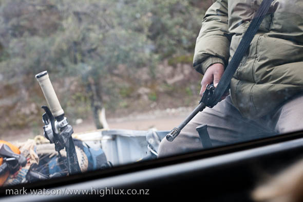
45 minutes later we’re being driven up the hill in the local police 4WD. We’re in the cab with the driver, and in the back are our two bikes, along with two don’t-fuck-with-us looking plain clothed police, both holding Colt Commando automatic rifles, and one with a black balaclava pulled over his head. Half an hour later we pull up outside a small hotel on the fringes of Cieneguita. The driver hops out, has a few words with the hotel owner and in no time we have a room and bed for the night.
It’s Christmas Eve and, in the midst of some epic food preparation, the hotel owner invites us into her house to sit by the fire, drink Tecate and munch on buñuelo (deep fried tortillas). Her generosity is awesome and it’s hard to drag ourselves off to our cold room. A small restaurant down the road is open and we cruise down there later to find some dinner. Our breath condenses in the air in the deserted room, but it’s better than huddling on a wooden palette in a half-built, abandoned house. Nothing on the menu appears to be available, so we take the only thing on offer: steaming pork soup – big chunks of meat sitting in broth and topped with onions and coriander. It’s awesome.
 Day 6 :: Cieneguita – Bahuichivo [53km]
Christmas breakfast is a packet of biscuits, a banana and half a can of Coke. We’re hoping this day will be easier after the mammoth climbing the previous day, and with a cold start out of Cieneguita we enjoy a few hours of undulating road that sidles along windswept forested ridges, topping out at about 2350 metres. Snow that fell a couple of days before sits on the shady aspects and the riding’s a welcome change from constant climbing. We’re feeling the altitude though, and heavy legs from the past two epic days, and stop often to keep the fuel coming in.
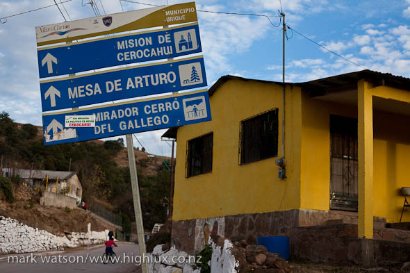
Eventually the road drops a few hundred metres and we hit the village of Mesa De Arturo for morning tea. Back on the bikes again, it’s an easy and mostly downhill ride to Cerocahui. After all that climbing we’re now back down to 1600 metres. Nestled in an open basin, Cerocahui’s a cool town, with a notable colonial cathedral and plaza area. We break for a bit here and eat lunch in a small café before riding an easy 15 km to Bahuichivo – our destination for the day.
Bahuichivo’s another scruffy town that Lonely Planet scarcely gives mention to, but it’s a stop on the famous Barranca Del Cobre railway and so has a couple of restaurants and hotels. It’s mid afternoon when we arrive and the town’s already half pissed, dressed in jeans, boots and cowboy hats and getting ready to party like only Mexicans can. We only just get a room in a very budget hotel before the owners and family bail off to their party. It’s just us, a bed that folds like a taco when we get in it, a TV that doesn’t go, and Tecate cans scattered everywhere.
We suss out our budget, realising that we can’t get any cash out in this town and I extract the note I’d stashed in my seat tube. We’re freaked when we realise it’s only a $50, and not the $500 we’d expected to see. Being a similar colour, I’d stashed the wrong note! With that our Christmas dinner budget took a pretty big hit, so we head out in search of a six pack to drink while looking for a cheap feed.
We’re sitting on a street corner watching the town revving up to party, sipping on our cans of Tecate and biding our time before dinner when a truck full of teenage boys yells out ‘Come with us! Come party with us!’
We exchange glances for a moment wondering if it’s a smart idea to get into a truck in the middle of nowhere in rural Mexico with a bunch of drunk teenage boys, but we’re bored, always keen to socialise, and looking for a bit of local contact. Clutching our beers we cram into the back of the cab and exchange pidgin Spanish and English in attempts to converse. We wind up at a derelict picnic area at a small dam, with a few other truck loads of drunk teenagers and stand around, slightly awkwardly, wishing we had enough Spanish to talk to them more.
We work out they dig trance, and they’re amazed when they realise we’re easily old enough to be their parents. It doesn’t stop us chopping back beers with them though and working out a few details about each others’ lives.
Next thing we know we’re piling back into the truck, fresh beers thrust into our hands, and heading back to the village. Talk turns to dope and the kids seem to be on a mission to score and are keen for us to join them and party more. The alarm bells ring a little, and with a bit of fast taking and mention of finding food we get them to drop us in town, despite their insistence that beer is all one needs. ‘Why eat?’
Our Christmas dinner is memorable for the fact that we ate all we needed for NZ$10 in a three walled hut on the roadside, while drunk locals cruised in an out picking up soft tacos and burritos. We’re in bed by 9 pm.
 Day 7 :: Bahuichivo – Creel [100km]
Knowing we have a huge day ahead we are on the bikes by 7.30 am. We’ve got to climb from 1600 metres back to mesa level at 2400 metres and shortly out of town the road tilts up and we’re grinding away. Punctuated by occasional short descents to link ridges together, we climb for 45 km and go through several shades of pain as our legs threaten to give up on us. It’s a pattern of eating, recovering a bit, and 30 minutes later feeling totally empty again, but we push on slowly knowing that once we hit the mesa near San Rafael the road will not only turn to seal, but will be a lot flatter.
The altitude has once again reduced us to a crawl as we top the climb and soon we’re in San Rafael looking to eat the town empty. Despite being told there’s no ‘banco’ or way to get more cash here, we manage to exchange a US bill for some pesos in the local shop.
We’re riding back out of town again by 1.30 pm, burping Heuvos Rancheros and hoping that the riding will be easy for the 55km to Creel. The terrain’s not quite what we’d prayed for though and the hours tick by as we make numerous short climbs, only to lose all the height again on steep descents. We burn off lunch after a couple of hours and stop to devour a cake we’d bought in San Rafael. It seems to be metabolised instantly, but half an hour later we’re sitting on the side of the road again eating bananas and dosing up on our last hit of Nescafe.
We push on and about 15 km out of Creel the sun finally dips below the horizon. Shortly after it’s dark, and dropping below zero. With numb feet, we dress up in our warm gear, strap head torches to our bikes and push on in the freezing dark. We pick up more tempo as the riding eases and the kilometre markers blink by a little quicker under our torch beams. There’s a final gauntlet to run into Creel though and as we fly down the hill into town two dogs sprint out barking feverishly. The faster of the two is making a beeline for my leg and I manage to unclip and give it a kick in the jaw as it makes its lunge. They give up, but Hana’s 100 metres behind and suffers the same attack – but this time with a dog on each side. Her scream’s probably heard all over town, but she makes it through with both legs intact.
It’s been an 11 hour ride and 100 km of dirt roads and seal by the time we unlock the van and collapse inside. The first margarita at Villa Mexicana tastes so good!
* * *
We found it pretty much impossible to collect good data and advice for this trip, so listed below a few details for future suitors:
Distances
Creel – Basigochi: 82km
Basugochi – Batopilas: 55km
Batopilas – Tubares: 66.5km
Cieneguita – Bahuichivo: 53km
Bahuichivo – Creel: 100km
Altitudes & info
Creel: 2377m (service town – lots of accom and restaurants)
Bottom of Copper Canyon (upper section): 1660m
Basigotchi: 2270m (dwellings only)
Kirare: 2000m (small shop on left)
La Bufa: 1010m (small shop on right)
Batopilas: 462m (3-4 restaurants and lots of accommodation)
Rodeo: 580m (shop on left near dirt plaza)
San Ignacio: 350m (couple of shops)
Tubares: 300m (1 shop on each side of river)
Piedras Verdes: 2060m (shop)
Cieneguita: 2200m (shops, accommodation and at least 1 restaurant)
Mesa De Arturo: 2300m (shop)
Cerocahui: 1600m (shops, restaurants and accommodation)
Bahuichivo: 1600m (shops, restaurants and accommodation)
San Rafael: 2180m (shops, restaurants, maybe accommodation)
Some useful links
Local mountain bike guide and good source of info: Umarike
3 Amigos (Creel-based guides with good info): here and here
Up-to-date local info here (cycling, climbing & travel): Outpost Wilderness Adventure
Check out Hana’s photos here.
We tracked the days from Batopilas most of the way back to Creel with our GPS, so if anyone would like a KMZ file to open in Google Earth showing the route, drop me an email.


Hi Hana & Mark , nice to hear from you and great photos thank you,
Having just read your comments of your epic ride through copper canyon, my legs feel sore in sympathy and my stomach empty so I need some espresso and a real breakfast followed by a wee lie down in the sun on something soft to recover.
Russell
Hey Mark, i’d love to check out the route you took. It’s my kind of adventure!
I hope the dog bites heal up quickly, pumps used to be a good deterrent but now they’re too small to be useful whackers.
Thanks for the write-up, I had flashbacks of one of the more adventurous sections of riding I have ventured on, trying to find a way from China’s Lugu lake to Tiger Leaping Gorge. Looking through your other stuff, it turns out I was recently in Joshua Tree just before you guys were there, small world!
cheers
adam
No worries Adam – emailed to you today.
Truly insane. Both of you.
yeah maybe… everything i have done since has been kinda boring by comparison!
You guys are both nuts!
yeah, probably… : )